Place
Introduction
A widely shared belief is that since 1945, literature and culture have become increasingly preoccupied with space at the expense of the great nineteenth-century problems of time and history. But space, place, and setting are not new questions in literature.
The sites and locales where a story's action takes place go a long way towards determining what that action may be. This is true of a text's geography, which supplies national and regional context, and of its specific setting (a particular house or a country estate, as in E. M. Forster's Howard's End, for example). A sense of place may be directly accessible to readers via specified locations, or it may be more ambiguously signaled via a constellation of allusions and a few broad references.
Computational methods, including named entity recognition and geocoding, allow critics to identify explicit geographic references in many texts. The resulting patterns of spatial reference have been used to analyse how national literature differs from one country to another, and how they change their spatial investments over time.
Often, literary settings also involve generic references to homes, rooms, city streets, and the like. For these general references, simple word counts may suffice to identify differences among texts.
Applications
Elementary
Geospatial data can be generated manually by using a tool like Google Maps to map literary locations by hand. See, for instance, The London of Sherlock Holmes, a map created by Bruce Wheeler that shows 400 identified Sherlock Holmes literary London locations. Similar work is possible using CARTO, a geo-visualisation tool that can come in useful when conducting a geospatial analysis of a novel or a larger corpora of texts. CARTO offers students a free account via GitHub’s Student Developer Pack. See for instance this map of modernist Paris that was generated using CARTO and try to generate a similar map of literary locations yourself. With a little more technical flair, paid tools such as ArcGIS StoryMaps can even be used to combine interactive maps with other multimedia content. For instance, see the project Aeneid: an interactive Voyage and navigate through the story map to find inspiration for how to use ArcGIS StoryMaps.
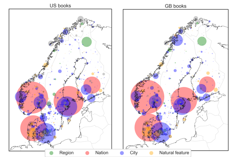
There are also freely available online tools allowing you to explore literary locations that have already been extracted. For instance, Textual Geographies provides a map visualisation of more than 14 locations extracted from 10 million books. See also the visualisation supplementing Evans and Wilkens, "Nation, Ethnicity, and the Geography of British Fiction, 1880-1940," CA: Journal of Cultural Analytics (2018), which displays different authors in a corpus on two principal components of a five-dimensional geographic feature space.
Lastly, The Group for Experimental Methods in Humanistic Research at Columbia University has made a web page containing a list of projects that you can explore and get inspired by.
Advanced
Recent advances in digital tools for GIS (Geographical Information Systems) technology have led to a rise in spatial digital humanities research (see Gregory, Donaldson, Murrieta-Flores, and Rayson, 2015), and the approach has been increasingly applied also in literary studies. Analysing the spatial aspect of literature through computational methods requires two steps: first, relevant locations need to be extracted from the text body using named entity recognition (NER). Second, a geolocation tool has to be applied to map the names with geographical locations.
Evans and Wilkens have mapped the geography of British fiction, focusing especially for the spatial representation of London in different corpora. All code and data to replicate their work can be found on Wilken’s GitHub repository. See also Wilken’s workshop to learn and explore the geographical dimension of literature. Pick a location often used in literature and carry out your analysis following the aforementioned examples. The “Geographic Locations in English-Language Literature, 1701-2011” by Wilkens and Ruan is a useful dataset for this purpose, already annotated with geospatial locations.
Alternatively, if you want to generate geospatial data yourself, the NER-tagging functions of SpaCy make it easy to detect locations in a text in Python, and the resulting list of locations can then be mapped with a geocoding tool, as is done in this tutorial. The Programming Historian also has several tutorials to get familiar with geocoding and mapping literary space.
Resources
Scripts and sites
-
Textual Geographies, an interactive visualisation of locations extracted from literature.
-
QGIS, open-source GIS software.
-
Matthew Wilkens' Geography of British Fiction and workshop for geocoding on GitHub.
-
Tutorials for geomapping in Programming Historian
-
Geocoding tutorial in Python with SpaCy
-
GitHub’s Student Developer Pack.
-
ArcGIS StoryMaps for digital storytelling combining text, maps and multimedia content.
- Aeneid: an interactive voyage into latin mythology.
Articles
-
Cooper, D., & Gregory, I. N. (2011). Mapping the English lake district: a literary GIS. Transactions of the Institute of British Geographers, 36(1), 89-108. https://doi.org/10.1111/j.1475-5661.2010.00405.x
-
Dunđer I., Pavlovski M., Seljan S. (2020) Computational Analysis of a Literary Work in the Context of Its Spatiality. In: Rocha Á., Adeli H., Reis L., Costanzo S., Orovic I., Moreira F. (Eds.) Trends and Innovations in Information Systems and Technologies. WorldCIST 2020. Advances in Intelligent Systems and Computing, vol 1159. Springer, Cham. https://doi.org/10.1007/978-3-030-45688-7_26
-
Evans, E. F., & Wilkens, M. (2018). Nation, Ethnicity, and the Geography of British Fiction, 1880-1940. Journal ISSN, 2371, 4549. https://doi.org/10.22148/16.024
- Gregory, I., Donaldson, C., Murrieta-Flores, P., & Rayson, P. (2015). Geoparsing, GIS, and textual analysis: current developments in spatial humanities research. International Journal of Humanities and Arts Computing, 9(1), 1-14. https://doi.org/10.3366/ijhac.2015.0135